Projects

On this page, you’ll find details about my current projects.
Association between Opioid-Related Injury and Built-Form Indexes Derived from Remote Sensing Data

Association between Opioid-Related Injury and Built-Form Indexes Derived from Remote Sensing Data

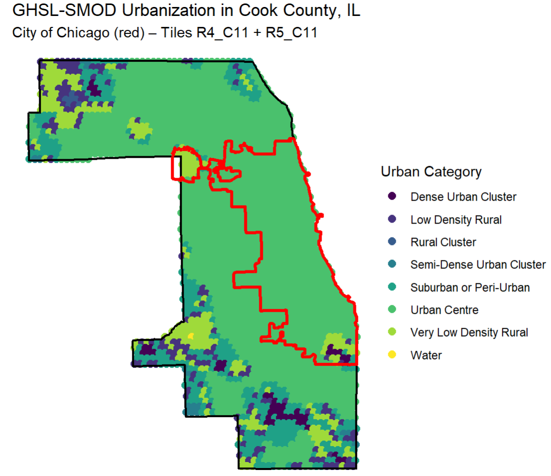
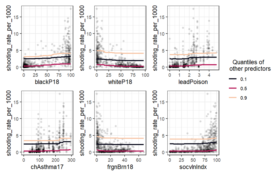
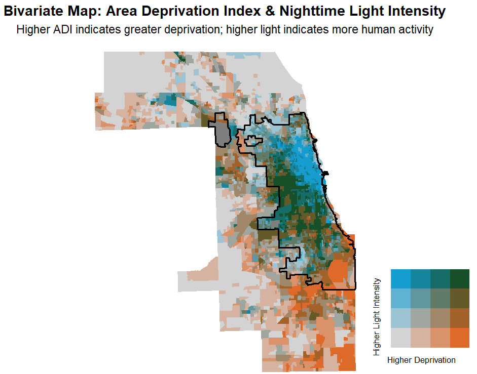
This project examines how built environment characteristics and neighborhood disadvantage interact to shape fatal opioid overdose risk in Cook County, Illinois. Using satellite-derived indicators—including urban development intensity, nighttime light emissions, and vegetative greenness—alongside spatial Bayesian models, we identify geographic clusters of elevated overdose mortality and assess environmental and structural risk factors at fine spatial scales.

opioid-crisis spatial-epidemiology remote-sensing bayesian-modeling urban-health environmental-justice chicago overdose
A Multilevel Analysis of Individual and Community Factors Associated With Case Dispositions Following Child Maltreatment Investigations

A Multilevel Analysis of Individual and Community Factors Associated With Case Dispositions Following Child Maltreatment Investigations

Using the Decision-Making Ecology Framework as a lens, the present study examines whether service disposition pathways are influenced by risk assessment, safety concerns, child age, maltreatment type, previous CPS involvement, and/or county-level structural vulnerability. We linked administrative data from New Mexico's Department of Children, Youth and Families (DCYF) to data from the American Community Survey.

academic ai machine-learning child-neglect spatial-analysis
AI-Driven Technology, Geospatial Analysis, Social Vulnerability, and Child Neglect

AI-Driven Technology, Geospatial Analysis, Social Vulnerability, and Child Neglect

This project uses AI-driven analysis of street-level images to examine how neighborhood environments—such as green space, lighting, and land use—shape child neglect risk. By linking detailed, objective environmental data to neglect rates, the study highlights how social and physical neighborhood conditions contribute to child well-being and can inform targeted prevention efforts.

academic ai machine-learning child-neglect spatial-analysis
Characteristics of blue and green spaces within and beyond highrisk suicide clusters

Characteristics of blue and green spaces within and beyond highrisk suicide clusters

Blue and green spaces, as well as areas prioritized for tree planting and park development, are associated with lower suicide risk.

child maltreatment multilevel model community factors case disposition
Spatial accessibility to gun violence exposure on walkable routes to and from school

Spatial accessibility to gun violence exposure on walkable routes to and from school

This study investigates the spatial accessibility of gun violence exposure along walkable routes to and from schools in Englewood, Chicago. Focusing on both direct and indirect forms of gun violence, the study uses acoustic detection technology to quantify the cumulative burden of gun violence exposure potentially encountered by students during their commute to and from school.

school commute violence computational spatial networks Englewood Chicago
Street View Measures of Urban Greenness, Area Deprivation, and the Risk of Firearm Homicide

Street View Measures of Urban Greenness, Area Deprivation, and the Risk of Firearm Homicide

We examined 899 firearm related and 2256 natural deaths in Cook County, Illinois, using a retrospective matched case control design. Greenness was assessed using the Normalized Difference Vegetation Index near death locations, tree canopy coverage, green space along walkable streets, and proximity of death to parks.

child maltreatment multilevel model community factors case disposition
Association between firearm injury and built-form

Association between firearm injury and built-form

This project uses built-form indexes derived from satellite data to investigate how urban structure and human activity intensity relate to firearm injury risk in Chicago.

firearm-violence remote-sensing flexurban chicago
Development and Spatial Validation of a Random Forest Prediction Model for Firearm-Related Injury Risk in Chicago Census Tracts

Development and Spatial Validation of a Random Forest Prediction Model for Firearm-Related Injury Risk in Chicago Census Tracts

This project develops and spatially validates a random forest model predicting non-fatal firearm injury.

bim python structural-engineering automation construction-technology real-time-analysis